The coastal zone stretching from northern California to southern Alaska is known as the North Pacific Coast. The physical geography is very wet and rugged. High precipitation patterns and heavy moisture makes for lush vegetation around the coast. Rainforests are plenty in the Olympic Peninsula where ferns, mosses, red cedars, Sitka spruces, and the worlds largest Douglas fir grows.
As stated previously, Santa Barbara, which is located in the Southwest Border Area in California, has a Mediterranean climate; onshore breezes make for a moderate climate with warmer winters and cooler summers. Santa Barbara does received precipitation in the winters. It has a higher rate of precipitation than most cities in the area but the summers are unaffected by rain.
Going back to trees, while Oregon has the biggest Douglas Fir tree in the country, Santa Barbara has the biggest Moreton Bay Fig Tree.
The North Pacific Coast's economy once relied heavily on fishing and forestry. The cold waters made for excellent fertile fishing grounds and British Columbia, Oregon, Washington, and California were easily the largest lumber producers.
Santa Barbara's economy is deeply rooted in the hospitality industry with science and technology being the basis of private employment.
[Sources]
http://www.ancientforestalliance.org/news-item.php?ID=20
http://en.wikipedia.org/wiki/Santa_Barbara,_California#Climate
http://www.clrsearch.com/Santa_Barbara_Demographics/CA/93111/Weather-Forecast-Temperature-Precipitation
http://en.wikipedia.org/wiki/Moreton_Bay_Fig_Tree_%28Santa_Barbara,_California%29
02 December 2011
Chapter 14 - The Southwest Border Area: Tricultural Development
The Southwest Border Area stretches from the Texas Gulf Coast to California's Pacific Coast past Central California. This region is rich in culture distinguished by Spanish American, American Indian, and Northwest European American people. Before American's took claim of this area in the 1830's, Spaniards occupied the Border Area, and before that even, American Indians arrived here more than thousands of years before.
The Chumash Indians started the history of Santa Barbara with approximately 8,000 - 10,000 Chumash living there. The Portuguese explorer Joao Cabrilho sailed through the channel in 1542 and in 1602, Sebastian Vizcaino gave the city its name. The Spaniards who did settle in Santa Barbara were missionaries and soldiers who came to build the Presidio and Santa Barbara Mission in 1872.
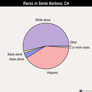
Currently, only 1% of the population is American Indian and Hispanic/Latinos make up 38% of Santa Barbara. The biggest demographic in Santa Barbara is the Anglo population.
The Southwest Border Area brings upon socioeconomic disparities, especially for the Hispanic and American Indian population. Along with African Americans, Hispanic and American Indians have the highest poverty rate in Santa Barbara, let alone California. Many American Indians are placed on reservations and the Santa Ynez Indian Reservation holds the only federally-recognized Chumash Indians in the country. 249 people reside on the reservation while other take homes just outside. The Santa Ynez Chumash population directly contributes to tourism by the development of the Chumash Casino Resort which brings in about 6,000 people a day.
*An interesting webpage about the Chumash Indians and their lives in Santa Barbara can be found here.
[Sources]
http://en.wikipedia.org/wiki/Santa_Barbara,_California
http://www.city-data.com/poverty/poverty-Santa-Barbara-California.html
http://www.santaynezchumash.org/reservation.html
Chapter 15 - California
In the text, California is described as "a central element in the American cultural fabric." California is looked at as the ideal lifestyle driven mostly by its image of its physical geography and laid-back, innovative manners.
Santa Barbara, which is located in Santa Barbara (which you already know this!) is definitely an ideal place to live/visit. It isn't called the American Riviera for nothing: it is one of the most beautiful cities in America. It offers picturesque beaches, Spanish-Mediterranean style architecture, has an incredibly wonderful and desirable climate, and has a sort of majestic beauty.
Unfortunately, California, and Santa Barbara obviously, lies along the most famous fault line, the San Andreas, making California susceptible to frequent earthquakes. As far as natural disasters are concerned, earthquakes are pretty much California's only downfall. Many believe that the 1906 San Francisco earthquake was among the biggest to hit California, however, the 1857 Ft. Tejon earthquake that hit Southern and Central California uprooted trees in the San Bernardino Mountains and caused the Kern River to flow backwards! It is approximated to have been about a 7.9 on the scale However, luckily for Santa Barbara, not much damaged occurred because of its proximity from the epicenter.
However, Santa Barbara has been home to many earthquakes that have started in that area; the 1812 and 1925 Santa Barbara earthquakes, the 1927 Lompoc earthquake, the 1902 Los Alamos earthquake, and the 1978 Goleta earthquake.
[Sources]
http://www.preservationnation.org/assets/photos-images/travel-sites/travel/dozen-distinctive-destinations/American-Riviera_mr.jpg
http://projects.crustal.ucsb.edu/sb_eqs/
Santa Barbara, which is located in Santa Barbara (which you already know this!) is definitely an ideal place to live/visit. It isn't called the American Riviera for nothing: it is one of the most beautiful cities in America. It offers picturesque beaches, Spanish-Mediterranean style architecture, has an incredibly wonderful and desirable climate, and has a sort of majestic beauty.
| GORGEOUS!! |
Unfortunately, California, and Santa Barbara obviously, lies along the most famous fault line, the San Andreas, making California susceptible to frequent earthquakes. As far as natural disasters are concerned, earthquakes are pretty much California's only downfall. Many believe that the 1906 San Francisco earthquake was among the biggest to hit California, however, the 1857 Ft. Tejon earthquake that hit Southern and Central California uprooted trees in the San Bernardino Mountains and caused the Kern River to flow backwards! It is approximated to have been about a 7.9 on the scale However, luckily for Santa Barbara, not much damaged occurred because of its proximity from the epicenter.
However, Santa Barbara has been home to many earthquakes that have started in that area; the 1812 and 1925 Santa Barbara earthquakes, the 1927 Lompoc earthquake, the 1902 Los Alamos earthquake, and the 1978 Goleta earthquake.
[Sources]
http://www.preservationnation.org/assets/photos-images/travel-sites/travel/dozen-distinctive-destinations/American-Riviera_mr.jpg
http://projects.crustal.ucsb.edu/sb_eqs/
01 December 2011
Chapter 13 - The Empty Interior
Chapter 13 deals with the Empty Interior: the United States' largest area of sparse population. Mountains and plateaus make up this large area. The climate is dry and arid and wildlife is diversified and populous.
Santa Barbara, on the other hand, is a Mediterranean climate, as stated previously. The city is right on the ocean so onshore breezes contribute to the city's moderate temperatures. Santa Barbara receives a winter rainfall, unlike the Empty Interior's aridity.
Mormon presence is abundant in the Empty Interior. About 1 in 7 people are Mormon. In Santa Barbara, a 2000 study found that 1.4% of Santa Barbara County's population was Mormon. The second popular religion following Catholicism.
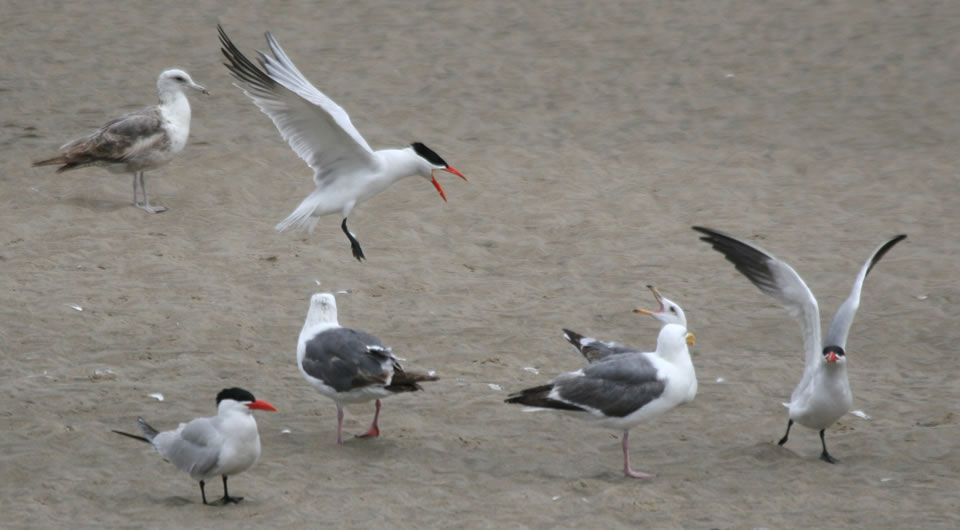
Chapter 12 touches on the wildlife of the Empty Interior. Buffalo, elk, antelope, deer, and wild turkeys are abundant. Since Santa Barbara is right on the ocean, many Brown Pelicans, Terns, and Swallows hang out.
*Just a funny fact: while Google-ing information regarding Santa Barbara and the Empty Interior, I came across some older student websites for this class! Made me chuckle.
[Sources]
http://crcc.usc.edu/research/demographics/santabarbara.html
http://en.wikipedia.org/wiki/Santa_Barbara,_California#Climate
http://www.calliebowdish.com/Birds.htm
Santa Barbara, on the other hand, is a Mediterranean climate, as stated previously. The city is right on the ocean so onshore breezes contribute to the city's moderate temperatures. Santa Barbara receives a winter rainfall, unlike the Empty Interior's aridity.
Mormon presence is abundant in the Empty Interior. About 1 in 7 people are Mormon. In Santa Barbara, a 2000 study found that 1.4% of Santa Barbara County's population was Mormon. The second popular religion following Catholicism.
Chapter 12 touches on the wildlife of the Empty Interior. Buffalo, elk, antelope, deer, and wild turkeys are abundant. Since Santa Barbara is right on the ocean, many Brown Pelicans, Terns, and Swallows hang out.
*Just a funny fact: while Google-ing information regarding Santa Barbara and the Empty Interior, I came across some older student websites for this class! Made me chuckle.
[Sources]
http://crcc.usc.edu/research/demographics/santabarbara.html
http://en.wikipedia.org/wiki/Santa_Barbara,_California#Climate
http://www.calliebowdish.com/Birds.htm
29 November 2011
Chapter 12 - The Great Plains and Prairies
Chapter 12 talks about the continuous plains and prairies that are located in the center of the United States. The landscape does have variation with it going from prairies to badlands which are created by sedimentary rock erosion. The Great Plains' weather is not identical to Santa Barbara; droughts, thunderstorms, tornadoes, and wind is not common in Santa Barbara.
Chapter 12 also discusses the countless novels, films, songs, and television shows about the Great Plains. In comparison, one book comes to mind when I think about Santa Barbara: Island of the Blue Dolphins by Scott O'Dell. The novel is based on a true story about Juana Maria who was left alone on an island on one of the Channel Islands off of the California Coast. In the end, she is rescued and taken to the Santa Barbara Mission.
Not so much ABOUT Santa Barbara:
[Sources]
http://en.wikipedia.org/wiki/Island_of_the_Blue_Dolphins
http://quarriesandbeyond.org/states/ca/images/santa_barbara_mission/ca-santa_barbra_missn_5471_gardn_juana_maria_plaq.jpg
http://en.wikipedia.org/wiki/Santa_Barbara,_California
Chapter 12 also discusses the countless novels, films, songs, and television shows about the Great Plains. In comparison, one book comes to mind when I think about Santa Barbara: Island of the Blue Dolphins by Scott O'Dell. The novel is based on a true story about Juana Maria who was left alone on an island on one of the Channel Islands off of the California Coast. In the end, she is rescued and taken to the Santa Barbara Mission.
Not so much ABOUT Santa Barbara:
- The final scene in The Graduate is set in Santa Barbara.
- Several scenes in the 1966 version of Batman were filmed at Stearns Wharf.
- The television show Psych follows a crime consultant in the city of Santa Barbara.
[Sources]
http://en.wikipedia.org/wiki/Island_of_the_Blue_Dolphins
http://quarriesandbeyond.org/states/ca/images/santa_barbara_mission/ca-santa_barbra_missn_5471_gardn_juana_maria_plaq.jpg
http://en.wikipedia.org/wiki/Santa_Barbara,_California
28 November 2011
Chapter 11 - The Agricultural Core
As stated previously, agriculture dominates the land use in Santa Barbara county. Strawberries, lemons, winegrapes, and vegetable crops are among the most fruitful in the area. Much of the success of agriculture can be attributed to Santa Barbara's climate. Elevations ranged from sea level to mountains over 6,000 feet giving Santa Barbara county various micro-climates which have naturally led to many agricultural regions.
The Santa Ynez Valley has been a big cattle-grazing land but until recently has become site for horse-breeding and wineries and vineyards.
The Lompoc Valley has prime soils which make it an ideal are for a variety of crops such as apples, cherries, and flower seeds.
The Santa Maria Valley is the prime agriculture trade center of the county. Many farm residences and agriculture processing plants are located in Santa Maria. One-half of the area's irrigated acres are vegetables and strawberries. More than half of the county's farm income comes from these crops. The foothills in the Santa Maria Valley are used as vineyards and beef cattle are grazed on the surrounding hillsides.
Santa Barbara's abundance of agriculture is also a negative aspect: it is also a leading source of water pollution. Rain water and irrigation water that washes over fields full of salts, metals, nutrients, and pesticides run off into the water nearby.
[Sources]
http://www.google.com/url?sa=t&rct=j&q=&esrc=s&source=web&cd=8&ved=0CFgQFjAH&url=http%3A%2F%2Flongrange.sbcountyplanning.org%2Fprograms%2Fgenplanreformat%2FPDFdocs%2FAgricultural.pdf&ei=T5LhTo_TBOariQLq-YWODw&usg=AFQjCNFBMWlIMSJqOpUf7jcjP-JlLMQLhw&sig2=haCH0MJIausOhZr_VbcWtw
http://www.sbck.org/index.php?option=content&task=view&id=7
The Santa Ynez Valley has been a big cattle-grazing land but until recently has become site for horse-breeding and wineries and vineyards.
The Lompoc Valley has prime soils which make it an ideal are for a variety of crops such as apples, cherries, and flower seeds.
The Santa Maria Valley is the prime agriculture trade center of the county. Many farm residences and agriculture processing plants are located in Santa Maria. One-half of the area's irrigated acres are vegetables and strawberries. More than half of the county's farm income comes from these crops. The foothills in the Santa Maria Valley are used as vineyards and beef cattle are grazed on the surrounding hillsides.
Santa Barbara's abundance of agriculture is also a negative aspect: it is also a leading source of water pollution. Rain water and irrigation water that washes over fields full of salts, metals, nutrients, and pesticides run off into the water nearby.
[Sources]
http://www.google.com/url?sa=t&rct=j&q=&esrc=s&source=web&cd=8&ved=0CFgQFjAH&url=http%3A%2F%2Flongrange.sbcountyplanning.org%2Fprograms%2Fgenplanreformat%2FPDFdocs%2FAgricultural.pdf&ei=T5LhTo_TBOariQLq-YWODw&usg=AFQjCNFBMWlIMSJqOpUf7jcjP-JlLMQLhw&sig2=haCH0MJIausOhZr_VbcWtw
http://www.sbck.org/index.php?option=content&task=view&id=7
Chapter 10 - The Southern Coastlands: On the Subtropical Margin
Chapter 10 discusses the Southern Coastlands of the United States which are comprised of parts of Texas, Louisiana, Mississippi, Alabama, Georgia, South Carolina, and all of Florida. This environment is categorized as subtropical; the climate is humid, the winters are mild, and the summers are hot. Santa Barbara, in comparison, is a Mediterranean climate which is actually a variety of the subtropical climate.
In contrast to the Southern Coastlands hazards of hurricanes and winter freeze, Santa Barbara's most prevalent hazard would have to be wildfires. The Jesusita Fire on May 5, 2009 burned more than 8,000 acres and destroyed over 80 homes. The fire burned through the Santa Ynez Mountains to the hills above Montecito.
Santa Barbara takes pride in the many fruit orchards it has all over the county. One successful crop that has cultivated in and around the county are lemons. Lemons are a subtropical fruit that bloom and bear fruit almost all year long. In 2007, over 1500 acres of lemons were grown in the Santa Barbara county.
However, Santa Barbara's most successful crop to date is the strawberry. In 2009, strawberries brought in a total of $299,442, 100.
“Agriculture... continues to provide a strong base for our local economy, and through the multiplier effect, agriculture and related activities had a total contribution in 2008 of more than $2 billion to the economy."
[Sources]
http://www.independent.com/news/2009/may/14/santa-barbara-endures-its-most-threatening-natural/
http://en.wikipedia.org/wiki/Jesusita_Fire
http://www.cfbf.com/counties/?id=42
http://www.noozhawk.com/local_news/article/041409_strawberries_remain_santa_barbara_countys_top_crop/
In contrast to the Southern Coastlands hazards of hurricanes and winter freeze, Santa Barbara's most prevalent hazard would have to be wildfires. The Jesusita Fire on May 5, 2009 burned more than 8,000 acres and destroyed over 80 homes. The fire burned through the Santa Ynez Mountains to the hills above Montecito.
| Satellite image of the Jesusita Fire burn scar on May 10, 2009, taken from the Earth Observing-1 (EO-1) satellite . Image shows the northern part of the burned area, which stretches from the outskirts of Santa Barbara (hidden beneath clouds) into the Los Padres National Forest. |
Santa Barbara takes pride in the many fruit orchards it has all over the county. One successful crop that has cultivated in and around the county are lemons. Lemons are a subtropical fruit that bloom and bear fruit almost all year long. In 2007, over 1500 acres of lemons were grown in the Santa Barbara county.
However, Santa Barbara's most successful crop to date is the strawberry. In 2009, strawberries brought in a total of $299,442, 100.
“Agriculture... continues to provide a strong base for our local economy, and through the multiplier effect, agriculture and related activities had a total contribution in 2008 of more than $2 billion to the economy."
[Sources]
http://www.independent.com/news/2009/may/14/santa-barbara-endures-its-most-threatening-natural/
http://en.wikipedia.org/wiki/Jesusita_Fire
http://www.cfbf.com/counties/?id=42
http://www.noozhawk.com/local_news/article/041409_strawberries_remain_santa_barbara_countys_top_crop/
Subscribe to:
Posts (Atom)