28 November 2011

Chapter 10 - The Southern Coastlands: On the Subtropical Margin

Chapter 10 discusses the Southern Coastlands of the United States which are comprised of parts of Texas, Louisiana, Mississippi, Alabama, Georgia, South Carolina, and all of Florida. This environment is categorized as subtropical; the climate is humid, the winters are mild, and the summers are hot. Santa Barbara, in comparison, is a Mediterranean climate which is actually a variety of the subtropical climate.

In contrast to the Southern Coastlands hazards of hurricanes and winter freeze, Santa Barbara's most prevalent hazard would have to be wildfires. The Jesusita Fire on May 5, 2009 burned more than 8,000 acres and destroyed over 80 homes. The fire burned through the Santa Ynez Mountains to the hills above Montecito.

Satellite image of the Jesusita Fire burn scar on May 10, 2009, taken from the Earth Observing-1 (EO-1) satellite . Image shows the northern part of the burned area, which stretches from the outskirts of Santa Barbara (hidden beneath clouds) into the Los Padres National Forest.


Santa Barbara takes pride in the many fruit orchards it has all over the county. One successful crop that has cultivated in and around the county are lemons. Lemons are a subtropical fruit that bloom and bear fruit almost all year long. In 2007, over 1500 acres of lemons were grown in the Santa Barbara county.


However, Santa Barbara's most successful crop to date is the strawberry. In 2009, strawberries brought in a total of $299,442, 100.


“Agriculture... continues to provide a strong base for our local economy, and through the multiplier effect, agriculture and related activities had a total contribution in 2008 of more than $2 billion to the economy."


 [Sources]

http://www.independent.com/news/2009/may/14/santa-barbara-endures-its-most-threatening-natural/

http://en.wikipedia.org/wiki/Jesusita_Fire

http://www.cfbf.com/counties/?id=42

http://www.noozhawk.com/local_news/article/041409_strawberries_remain_santa_barbara_countys_top_crop/

15 October 2011

Chapter 9 - The Changing South

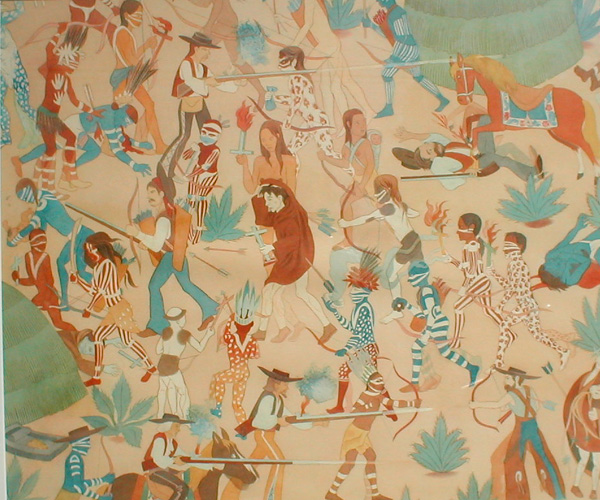
California was not part of the changes of the South, including slavery of the African people. However, in comparison to the idea of slavery, many argue that the Spanish missionaries enslaved the Indian people. The idea of slavery in the context may not directly compare to that of the African slaves, but the Indian people were subjected to rapid and violent social and cultural change. The Indian people were pulled from their homes, traditions, families, and made to adapt to a new culture and values. Many forcefully did not submit to this new ways of life and ultimately were violated and subjected to slavery unintentionally.

A little hard to see, but a painting of Indians playing music at the Santa Barbara mission.


Add caption


A painting showing the Chumash Indian's revolt at the SB Mission.

[Sources]

http://www.sandiegohistory.org/journal/78spring/labor.htm

http://digitallibrary.usc.edu/search/controller/view/chs-m2626.html

http://americangallery.wordpress.com/tag/american-west/

http://www.sito.org/cgi-bin/egads/showart?show=ham.0129

14 October 2011

Chapter 8 - Appalachia and the Ozarks

The Appalachians and Santa Barbara don't really have much in common. The Appalachians topography made it difficult to be used in farming and settlement. However, Appalachia became significantly known for its mining, most notably coal. However, it had a big negative impact on Appalachia's physical geography making it undesirable to live. Poverty rates in the Appalachia's is significant, mostly in Southern Appalachia cultures.

Santa Barbara, in comparison, has had some issues with its physical geography and farming; the county being hilly and including lots of forest. However, Santa Barbara county has found ways to to go around this and has hundreds of successful wineries. The Coal Oil Point in Santa Barbara is the largest oil seep in the world. It hasn't adversely affected the area as much as the Appalachia's farming did, but the oil seep does produce tar balls that wash up on the beach. Also, the oil seep is a natural occurring process whereas the people in the Appalachia's farmed and created the problems. On the topic of poverty, in the 2000, the census data report stated that 13.4% of Santa Barbara's residents were below the poverty line. The per capita income for Santa Barbara then was $26,466. This compared to the actual cost of living shows that the number of people below the poverty line is quite high.


Satellite map of petroleum seep.


[Sources]

http://en.wikipedia.org/wiki/Santa_Barbara,_California

11 October 2011

Chapter 7 - The Bypassed East

Santa Barbara is not included in the Bypassed East. Santa Barbara has been inhabited by people for over 13,000 years. Currently, it is a very popular place to live and visit. There are many neighborhoods with distinct history, architecture, and cultures.


Santa Barbara neighborhood map.


Spanish influenced homes.


Santa Barbara marina.


University of California Santa Barbara.


As specified previously, tourism alone gives the Santa Barbara economy more than a billion dollars per year.


State Street.

Stearn's Wharf.


[Sources]

http://www.danaoneill.com/santa-barbara-neighborhoods/

http://express.ece.ucsb.edu/pictures/aerial_campus2.html

http://www.worldofstock.com/stock_photos/TAC3417.php

http://www.engr.uconn.edu/~garrick/ce254/ce%20254%202009/lecture%20and%20home%20work%20index%202009.htm

05 October 2011

Chapter 6 - All about Canada

Since Chapter 6 is supposed to be skipped, considering I'm not blogging about Canada, I thought I would include an interesting crop report on Santa Barbara. (pdf file)

Agricultural Production Report 2009

29 September 2011

Chapter 5 - The North American Manufacturing Core

Santa Barbara is widely known for its wonderful wineries and wine trails. Spanish missionaries planted the first wine grapes in the 1800's on the grounds of the Santa Barbara Mission. Many know Santa Barbara as Wine Country, which also extends up north to include places such as Sonoma, CA. Santa Barbara has become a prominent viticultural region (viticulture meaning the study and harvest of grapes). The grapes in this county are are now among the highest priced wines in the state. Santa Barbara is known as an American Viticultural Area (AVA).


Rancho Sisquoc - one of the first wineries in Santa Barbara County.


Santa Barbara county now has more than 115 wineries. Included in the Santa Barbara Central Coast AVA is the Santa Maria Valley AVA, Santa Ynez Valley AVA, Sta. Rita Hills AVA, Los Olivos AVA, Ballard Canyon AVA, and the Happy Canyon AVA.

One of the most widely known wine trails is the Foxen Canyon Wine Trail which includes Foxen Winery and Rancho Sisquoc, among others.


[Sources]

http://www.ranchosisquoc.com/

http://en.wikipedia.org/wiki/Santa_Barbara_County,_California

http://www.foxencanyonwinetrail.com/

http://www.santabarbara.com/winecountry/trails/foxenvalleytrail.asp

Chapter 4 - Megalopolis

Located in the California megalopolis, Santa Barbara is 13th in rank in urban agglomeration. The largest being the Los Angeles area. Santa Barbara is located off the 101 freeway which links the city along the coastal regions of California. Santa Barbara also has its own airport and access to an Amtrak service. The Santa Barbara Metropolitan Transit District provides bus services across the city. There are also numerous amounts of biking trails. Santa Barbara boasts being a car free area with its project Santa Barbara Car Free. It does not mean there are no cars, it just means anybody can get around Santa Barbara without the use of a car!


Santa Barbara is known for its many tourist attractions and big hospitality industry which has had a major impact on its regional economy. The motel chain, Motel 6, was actually started in Santa Barbara in the 60's. Firms like Alliant Techsystems and Raytheon have major operations in the city. Science and technology form the basis of the city's private employment.


According to the City's 2010 Comprehensive Annual Financial Report the top employers in South Santa Barbara County are:
# Employer # of Employees
1 University of California, Santa Barbara 6,200
2 County of Santa Barbara 4,000
3 Santa Barbara Cottage Hospital 2,500
4 Santa Barbara City College 2,000
5 Santa Barbara School Districts 1,800
6 Raytheon 1,500
7 Sansum Clinic 1,500
8 City of Santa Barbara 1,000
9 United States Postal Service 1,000
10 Santa Barbara Bank & Trust 950


Tourist attractions not only include Santa Barbara's beautiful beaches, but the Santa Barbara Mission, the Presidio, the Santa Barbara Courthouse, and Stearns Wharf. On top of these attractions, SB is home to many performing arts venues like the Arlington Theatre, the Lobero Theatre, and the Santa Barbara Bowl. SB also has festivals including the annual Fiesta, the French Festival, the Santa Barbara International Film Festival, and the Summer Solstice Parade. Santa Barbara also has an abundance of seafood restaurants and wineries. Santa Barbara also is home to many schools and universities including a research university, liberal arts colleges, a community college, trade schools, a conservatory, and many high, middle, and elementary schools.


[Sources]

http://en.wikipedia.org/wiki/Santa_Barbara,_California#Geography

http://www.santabarbaracarfree.org/

http://www.lkjh.org/bike/california/santa_barbara